In September and October, 2025, Bron and I enjoyed two Intrepid trips. One to Peru, including the Amazon basin, Machu Pichu and Lake Titicaca. The other to the Galapagos Islands. In between we spent some time in Quito (Ecuador) and the surrounding area.
Check out the photos from the Peru trip
Also the photos from Quito and the surrounding area.
If you just want to see some humming birds!
Also, I got a little obsessed with 'walk' traffic symbols.
This was the third time I'd tried to do the South Coast Track in Tasmania. The first two times hadn't happened for various reasons. But this time it would.
Between 29 December 2024 and 6 January 2025 eight of us, two guides and six intrepid hikers completed the 85 kilometre track from Melaleuca in the south west corner of Tasmania to Cockle Creek. in the south east corner.
Check out some photos of the trip
Day 1 - Flew from Hobart to Melaleuca
Day 2 - Melaleuca to Point Eric
Day 3 - Point Eric to Louisa River
Day 4 - Louisa River to Little Deadmans Bay
Day 5 - Little Deadmans Bay - lay day
Day 6 - Little Deadmans Bay to Osmiridium Beach Camp
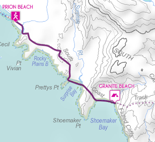
Day 7 - Osmiridium Beach Camp to Granite Beach
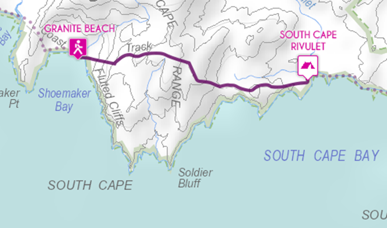
Day 8 - Granite Beach to South Cape Rivulet
Day 9 - South Cape Rivulet to Cockle Creek
Big Thanks to the TrekTasmania Guides, Mitch and Alina and to my fellow hikers, Jane, Jerone, Tim, Brendan and Phillip
On our first expedition to cross Bass Strait Bob and I had paddled from
Victoria to Deal Island and back.On
our second expedition we’d paddled from Tasmania to Roydon Island and
back.I claimed that, by going to all
the ‘crossing’ islands, we’d ‘done’ the Bass Strait crossing.However, we hadn’t paddled the biggest
section, from Deal Island to Roydon Island.Also, we’d loved our one day on Deal Island and were keen to get back
there.So a third expedition was
planned.This time with the specific
aim of getting to Deal Island and spending some time there.
The plan was to maximise our opportunity to get a weather window to
paddle to Deal from Roydon and another to get back to Flinders Island.So, we organised transport to and from Lady Barron
on Flinders Island with 21 paddling days available.The previous expeditions had involved more
people but this time it was just Bob and me.The question was whether we would kill each other with so long together.
On Sunday 2nd February 2025 we caught the overnight ferry
from Geelong to Devonport.We then
drove to Bridport on the Tasmanian north east coast.We’d organised to take the Bass Strait Freight
ferry from Bridport to Lady Barron.However, the boat can only leave Bridport at high tide, which wasn’t
until 4.30 a.m.We spent the
day/afternoon/evening having a look around Bridport, getting our gear together,
eating, particularly steak at the pub, playing pool at the pub and trying to
have a nap in the car.At 2.30 a.m. we
were at the dock, loading our kayaks and gear onto the boat.Now for the 8 hour trip to Lady Barron.
It was a calm crossing of Banks Strait.
Sunrise was beautiful and the various birds whirled around
overhead. We could see the mountains on
Cape Barron and Mount Strzelecki on Flinders Island.
Frankland Sound was particularly pretty as we passed numerous
islands. We arrived at Lady Barron at
11.30 a.m. Our kayaks were offloaded
and it was time to get organised for the start of our big expedition.
It was Tuesday (4 February) and it looked like there would be a weather
window on Friday.That meant we had two
and half days to get to Roydon Island, approximately 70 k from Lady Barron.We wanted to get as far as we could on
Tuesday afternoon.It was a headwind
(westerly) and strengthened as we paddled.We managed to make it to Pigs Head Point (12 k) on the south side of
Flinders.We found a pretty, small bay,
sheltered from the strong westerly.There was a couple of good spots for our tents and we had time to
explore the headland with the Pigs Head Point beacon.
Wednesday, 5 February It had been a windy night and a fresh south easterly was blowing. There were lots of white caps out in the
Sound. It wasn’t ideal for paddling but
we needed to get up the coast to make the Friday weather window. We headed out onto the water. There was reasonable size waves and it was
very messy around Trouser Point. My
knee slipped out from bracing and I found myself going over. Fortunately a big support stroke got me back
up. I wasn’t exactly enjoying the
paddle.
We needed some water so decided to call in at Trouser Point camping
ground. The south facing beach was too
exposed so we paddled around to the other side of the Point at Fotheringate
Bay. After wandering around for a while
we realised that the camping ground was further away than we realised and
decided to press on. Fotheringate Bay was
sheltered from the wind and we broke out the sails for a pleasant ride.
At Long Point we stopped for lunch.We were making good distance.We
then headed across Sawyers Bay to Settlement Point.The bay was more exposed and the waves were
higher and the wind stronger.We
actually found that the sails helped stabilise the kayaks on the waves and we
were roaring along.It was a bit
stressful but also exhilarating.
We dropped the sails before Settlement Point and paddled into the
shelter of Port Davies. We managed to
cover about 45 k. It took us a little
while to find Allports Beach where there was a camping ground. Allports is a lovely sheltered beach which
is very popular with the locals. There
were great facilities including bbq, toilets and change rooms but the camping
ground was long way from the beach and was pretty average. We decided to camp in the sand dunes, the
locals didn’t seem to mind.
Thursday, 6February It was only 15 k across Marshall Bay to Roydon Island. There was a fresh easterly wind so no
sailing but it only took us a couple of hours.
Now we needed to prepare for the paddle to Deal Island on Friday.
The wind on Friday would be a light easterly/south easterly but it was
due to change to the south west and strengthen late in the afternoon. We would need to reach Deal before the
change. We wanted to leave as early as
we could so we had enough time and wouldn’t end up battling into a headwind
when we were exhausted. That meant
leaving Roydon at night. We walked
around the island looking for hazards.
There were lots of rocks on the eastern passage which we didn’t fancy in
the dark. The western side looked a lot
better. Bob plotted a route around the western
side of the island on the GPS. We spent
the rest of the afternoon preparing for the paddle, enough food and drink and
working out bearings and routes. We
decided to stay in the hut to avoid having to pack up tents. The local birds were delightful with lots of
pretty silver eyes around the hut water tanks.
Friday, 7 February We got up at 3.00 a.m. and prepared to depart at 4.10 a.m. We had our white navigation lights on and we
used cyalume sticks to light up our compasses.
The green ones worked better than the red ones. It was calm as we left Roydon and followed
the route around the island. There was
only one moment when a large rock loomed out of the dark and when we paddled
over another one. Once we were clear of
the island we used stars for our compass course. As the sky lightened we switched to following
the compass bearings.
The sunrise was spectacular and fairly soon flocks of sea birds appeared
and swirled around. At one stage there
was over 100 bird sitting on the water.
We got into a routine of a five minute break every hour. As we neared the break Bob would read out
the GPS information, how far from the course we were, the distance covered, the
distance and time to go. It was a hazy
day and we couldn’t see Deal at all. At
one point Craggy Island appeared far off in the mist, but that was about all we
could see.
It was only when we were about 500 m away from Deal Island that we
started to see the cliffs and to hear the breaking waves.It was disconcerting to be close to cliffs and
not really be able to see them.We had
decided to go to Winter Cove.It was
the closest camp location to Flinders and we hadn’t been there before.We approached Winter Cove from the south,
along the cliffs.Immediately to our
left were the breaking waves on the cliffs.To our right were more breaking waves, on a large rock at the southern
end of the entrance.There were now
large swells so we were negotiating a narrow entrance and disconcerting
swells.It was a relief to get into the
cove where the waves were calmer.
We could see the sand of Winter Cove in front of us. However, there were large breaking waves
between us and the sand. Bob went first
and I could see him safely on the beach.
It was now my turn. I turned on
my bilge pump and paddled my heart out, keeping the kayak straight on the
wave. It was one of the best surfs I’ve
ever had. It had taken us 12 hours to
cover the 65 k from Roydon Island to Winter Cove.
There was a camping area at the southern end of the cove.We set up our tents, cooked dinner and sent
the Garmin message that we had arrived safely.
Saturday 8 February It was a windy night and we were happy that we’d managed to get a window
to paddle to Deal. After breakfast we
decided to head over to the other side of the island. At the top of the track from the beach we
found a couple of jerry cans full of water for the use of people at Winter
Cove. This was definitely a bonus. We then walked the 4 k over to the western
side of the island. First to the mobile
phone chair. This is actually a chair
on the track to Garden Cove. From the
chair there is a direct line, through the gap between Erith and Dover Islands
to Victoria and telephone towers. There
were calls to family and friends to reassure them that everything had gone
well. We also checked the weather. Strong easterly winds were forecast for the
week. We then headed over to the old lighthouse
keepers buildings, including the museum and the caretakers’ residence. That was when everything changed.
After having a look around the museum we came across the
caretakers. A pilot had reported a fire
on Deal Island and the caretakers, John and Ros, had been asked to walk up to
the lighthouse and report back. There
was indeed a fire and it was on a headland not far from the lighthouse. We followed John and Ros into the
caretakers’ house as they reported back to the Parks Service. They gave us a cup of tea and chips as we waited
to find out what was going to happen next.
While we were waiting a group of sailors from a yacht arrived and were
also advised of the fire.
Finally there was a plan. Parks
sent in a helicopter with an initial fire crew. They did a recon of the fire on the way
in. It was near Squally Cove, not far
from the lighthouse. The lighthouse was
historic and had been badly damaged by fire in 1995 and restored. They didn’t want this fire to get to the
lighthouse, however the crew were confident that they would be able to put it
out the next day, with some water bombing tonight and tomorrow. We were to head back to Winter Cove and stay
there and the sailors were to stay on their yacht in East Cove.
Back at Winter Cove we got to know the locals better. The red necked wallabies (or Bennett’s
Wallaby) were very curious about our food.
They even understood the phrase ‘Dinner’s ready’. Prodding them with sticks didn’t result in
any response and they just ducked projectiles.
Banging pans together slightly deterred them but not for long.
Sunday 9 February We hadn’t counted on not being able to explore the island. Although we’d been to Deal once before, we
were keen to go back to the lighthouse and other areas. Pegleg Bay was to the north of Winter
Cove. There was a walking track and it
was further away from the fire so we decided on a bit of exploring.
Pegleg Bay has a rocky beach. You
wouldn’t want to land there in a kayak.
We scrambled along one headland and were rewarded with excellent views
north to Pulpit Rock and Garden Point and north east to Anvil Rock and North
East Isle, with its beacon. We then
walked over to the main settlement for an update on the fire. There was lots of firebombing going on and
the firefighters were hoping to leave tomorrow. John and Ros were working in the vegetable
garden so we checked it out. It was a
large area enclosed in wire and protected from the wind. There were ripe tomatoes calling out to be
picked and lots of beans, green leafy vegetables and vines. As caretakers only stayed for 3 months they
worked hard in the vegetable garden for other people to enjoy. And they reaped the rewards of other
people’s work.
Monday 10 February Still windy at Winter Cove. We
decided to explore Barn Hill, above the main settlement. As we walked across the island we could see
lots of smoke coming from the fire. It
didn’t look like the firefighters would be leaving today. The fire was actually looking worse. At the main settlement, we met up with the
sailors. It was too windy to leave Deal
Island and they were getting bored sitting on their yacht. John and Ros then called us all into the
caretakers’ residence.
The fire situation had deteriorated.
The head ranger was closing Deal Island. This meant that the sailors had to stay on
their yacht until they could leave. Ideally
we were to leave the island but as this wasn’t possible (due to the strong
winds) we had to relocate to Garden Cove (initially it was to the main
settlement and later this changed to Garden Cove). There was discussion about Parks possible
evacuating us all from the island. If
that happened we would have to leave our gear including our kayaks, and
consequently may never see them again.
As Bob and I walked back to Winter Cove to pack up our camp, we
discussed our options. We decided to
take everything with us to Garden Cove, including our kayaks. At Winter Cove we packed up our camp and
started moving everything to the bottom of the track out of the Cove. The first step was to see if we could
actually lug the sea kayaks to the top of the cove track. This involved hauling them up 150 metres in
height. We took one at a time, sliding
them along the grass and lifting them over rocks and then up the steep track. Getting both to the top was a major
achievement. We then carried all our
bags up from the beach. There were numerous trips up and down the steep track.
We had just about moved everything to the top of the track when John
arrived in the caretakers’ buggy (called a Polaris). John was putting up signs saying that the
island was closed and that anyone arriving had to leave. He was surprised that we had managed to carry
everything, including our kayaks, up from the beach. We loaded our bags into the back of the
Polaris. The plan was for John to take
our bags but we would have to move our kayaks.
John took off.
Our plan was to slide the kayaks as much as possible along the
grass. While we were experimenting with
different ways of protecting the bows of the boats, John returned with Ros. The Parks people wanted to know why it was
taking us so long to move and wanted us at Garden Cove as soon as
possible. The sliding plan was ditched,
John would help us carry the kayaks.
Ros drove the Polaris while John, Bob and I carried the two kayaks.
We carried the kayaks about 4 k and left them at the telephone
chair. Ros took our gear down to Garden
Cove. We’d managed to move all our stuff
a distance of 5.2 k. Bob’s dinner of
chicken green curry tasted pretty good that night! We sent a message saying that we’d relocated
to Garden Cove but not how we’d got there.
We got a couple of responses, impressed that we’d paddled despite the
strong wind!
Over the next few days the wind was still strong and we weren’t able to
leave Garden Cove and Deal Island.
Every morning we’d receive a message from the caretakers on the Garmin
with an update. Every day we saw
helicopters, often with the bucket and one day we saw a light plane taking off
from the nearby landing strip. Yachts
anchored in the cove, staying for a night or two and then leaving. A white bellied sea eagle was a resident in
the cove, either sitting in a lookout tree or soaring around the bay. We carried our kayaks from the telephone
chair to our campsite. We swam and
walked to the top of the nearby headland.
We found a cairn on the top of the headland. Apparently a lot of cairns were built on the
various hills. From the headland we got
some great views of Garden Cove, around to Anvil Rock and North East Isle and
then across Marshall Pass to West Cove and Erith Island. During one swim Bob spotted a large stingray
gliding along the breakers. We were a
bit weary of the ray and started to walk back to shore. The ray then circled back behind Bob and as
he moved he stepped on the ray. The ray
wasn’t fussed but Bob was! We had got
into the habit of eating our meals in the shade and shelter of a grove of trees
overlooking the beach. It wasn’t a bad
life.
Friday 14 February Finally, the wind was forecast to ease for about 6 hours. We took the opportunity to leave Garden Cove
and Deal Island and head to Erith Island.
Once we got out of the shelter of the cove there were large swells from
days of strong winds. We went with the
tide into Murray Pass and across to West Cove, on Erith Island. We could now look back to East Cove on Deal
Island, see the lighthouse and the smoke from the fire.
We landed at the northern end of West Cove, and checked out the hut, to
make sure we would be able to camp there.
We wanted to make the most of the calmer conditions and do a bit of
exploring along Erith and Dover Islands.
There were three boats in West Cove so we paddled up for a chat. No response from one yacht. The next was a lovely yacht from
Sandringham, called Belle. They were
happy for a chat. The last one was a
launch and was guarded by a small white dog.
The boat was rolling a bit and we asked after the dog. Apparently he’d lived all his life on the
boat so was pretty comfortable.
However, he’d recently last his tender and could only get the dog ashore
on a bogie board.
We headed south to Nautilus Bay, which is the bay between Erith Island
and Dover Island. At low tide the two
island are joined by rocks but at high tide it is possible to paddle between
them. The location is called the
Swashaway. We could see the water, and
waves, on the western side of the Swashaway.
It didn’t look like a great place to paddle unless it was very
calm. We then paddled along Dover
Island to Norfolk Point and then across Dover Bay towards West Bluff. We could see standing waves across the
entrance to the channel. There was also
a strong westerly wind funnelling through the saddles. As the tide roared in from the east, the
water met the large swells coming in from the west, forming not only the
standing waves but large boils, particularly on the points. We then turned around and returned to West
Cove and our home for the next few days.
Erith Island is a beautiful and interesting place. Archaeologists found Aboriginal artefacts
dated to 9,000 years ago. The first
Europeans to sight the island was in 1798 by the schooner, Frances, as they
rescued the survivors from the wreck of the Sydney Cove on Preservation
Island. By 1800 there were sealers
living on the island. Later cattle were
farmed there. It is now a National
Park. The hut was built in 1958 by Jack
and Gladys Lierick from driftwood and lined with sails. They apparently lived there for 4
years. In the 1960s the Murray-Smith
family began making trips to the island with friends. They are known as the Erith Mob and still
come to the island every summer. They
also maintain the hut.
We settled ourselves into the hut.
The view across to Deal Island was spectacular. After a lunch of pumpkin soup and some
clothes washing we went out to explore.
There was a track over to the western side of the island which gave us
phone coverage. We had a new ‘phone
box’.
Saturday 15 FebruaryThis was a very wet and windy day.In between the showers we managed to do some more exploring.We found the cairn to Stephen Murray-Smith,
who had spent numerous summers on Erith Island.We also found the grave of George
Phillpotts.He was only 18 when he died
on HMS Myrmidon, during a surveying voyage.We then scrambled up the saddle at the southern end of the beach.It was quite a climb and there were dramatic
views across to Dover Island and the Swashway.That night there was a big storm with heavy
rain and strong winds.It was very nice
to be in a hut rather than our tents!
Sunday 16 February Our first task was to walk to the ‘phone box’ and check the weather
forecast. Initially it looked like
there was a window to paddle back to Flinders Island on Monday but more recent
forecasts had looked less hopeful. It
was possible that we would have to wait until Thursday or Friday. However, as we both looked at the weather
apps, we realised that Monday was going to work. We’d be able to paddle tomorrow!
From the ‘phone box’ we walked down to Wallabi Cove, a pretty sheltered
rocky cove. We then walked to the top
of the headland. This looked like it
was going to be pretty straightforward.
However, there was a band of thick shrubs between the grasslands and the
open casuarina forest at the top. We
ended up crawling under and climbing over shrubs. It was hard work and energy sapping. We finally made it to the top. I ended up climbing up a tree to set a good
photo of the view.
We found a better
viewing spot, which was much easier to get to, on the southern side of the
saddle. The view south towards the
Swashaway and along Dover was spectacular.
We walked back to the hut and prepared for our departure the next day.
Monday 17 February We had hoped to paddle around Deal Island or at least past the
lighthouse and the dramatic cliffs beneath it.
The strong winds hadn’t made that possible. We contemplated trying to paddle past the
lighthouse as we returned to Flinders Island.
However, the tide meant that we had to paddle out the northern end of
Murray Pass so no lighthouse. We got up
at 4.30 and left at 6.15 a.m. The sun
was rising as we paddled between Deal Island and North East Isle.
We once again got into our routine of a five minute break every hour.There was a slight breeze from our
beam.This time our course took us
close to Wright Rock.As we approached
the rock we started getting rebound and there were standing waves on the other
side.A large colony of seals were
lounging on the lower slabs of rock.We
could hear the barking of the seals and after we past we could smell the seal
colony.Neither of us had wanted to
take our hands of our paddles so unfortunately no photos of the rock or the
seals.
We could also see Craggy Island off to our left and Flinders Island
ahead. As we got closer to Flinders a
slight north westerly wind sprung up.
We put our sails up, keen for any assistance we could get.
We could now head straight for Roydon Island. We weren’t far away from the island and everything
was looking fine. We would soon be
there. It was then that I realised that
we weren’t making headway. The tide was
against us. I tried paddling harder but
didn’t have the energy to keep that up and it didn’t seem to make any
different. I couldn’t believe it we
were so close. Bob reassured me that we
were making headway, about 3 kph. He
suggested putting our sails back up to get all the help we could. We then took a long break while the sails
slowly edged us forward. The wind was
now against the tide and we knew that there was lots of rocks on the inshore
route to the beach on Roydon. However,
the tide and waves looked worse on the other side. We stuck with the inshore route and kept the
sails up. There was some manoeuvring
away from surf waves and rocks before we were safely in the bay and then
finally on the beach. We were both
stuffed. It had felt harder than the
crossing to Deal. It had taken us 12½ hours
and we’d covered 71 k! We slowly
unpacked the kayaks and carried our gear up to the hut. Curiously the hut smelt strongly of fish.
Tuesday 18 February There were lots of bird noises during the night. Turned out that there were penguins near and
under the hut. The chicks make a lot of
noise when they’re hungry. Perhaps that
was why the hut smelt of fish! The wind
strengthened but we weren’t looking to paddle anywhere anyway. We spent the day drying gear, lying around,
napping and reading. We didn’t have
much energy for anything. Interestingly
we were now under the flightpath of the helicopters going to and from Flinders
to Deal for the fire.
Wednesday 19 February It was
still very windy so another day on Roydon Island. We walked to the top of the island, which
gave great views down to Mount Strzelecki and across to Deal Island. There were a lot of white caps and waves
pounding the rocks. A small motor
launch anchored in the bay. We then had
four visitors from ‘Alcheringa’. She
was a wooden launch from Port Franklin and was on her way home after attending
the Wooden Boat Show in Hobart. The
skipper had done a lot of cruising around the islands of the Furneaux and Kent
groups. He was very knowledgeable and
we had a good chat. They were waiting
for the wind to ease and were doing some fishing including for crayfish.
Thursday 20 February Time to leave Roydon Island. We
said goodbye to the crew of Alcheringa.
We were heading to Whitemark and civilisation! We paddled south across Marshall Bay to Wybalenna
Island. We found a small beach and
stopped for lunch. It was then on to
Long Point. As we paddled a couple of Common
Dolphins played around our kayaks, diving under the boats and swimming beside
us. Once we were around Long Point we
were able to set our sails for a gentle paddle/sail to Whitemark. Whitemark is the largest town on Flinders
Island and is only accessible by water at high tide. We’d timed our arrival for the tide and also
for the pub! There wasn’t a camping
ground so we decided to camp in the dunes.
We didn’t want to cause any problems so we hid our gear and kayaks.
We headed into town and sussed out the shops, particularly the bakery,
café and supermarket. Then made our way
to the Interstate Hotel for dinner. The
Interstate is a lovely old hotel built in 1911. We were very conscious that we were
underdressed and probably looked pretty scruffy. It was actually quite surreal to be sitting
in a hotel, reading a menu and drinking alcohol. We treated ourselves to main course and
desert!
Friday 21 FebruaryWe had to wait until high tide to leave Whitemark so that gave us the
opportunity to make the most of civilisation.First up was the bakery for breakfast.Then we checked out the supermarket.We then walked to the Bluff, to the north of Whitemark.There were lots of waterbirds feeding on the
mud flats and a couple of yachts with bilge keels so that they sat on the mud,
rather than their side at low tide.There were great views across the mudflats to Mount Strzelecki.Our walk took us along Boyes Road.There is also a Boyes Rock and a Mount Boyes
on Flinders.Back to Whitemark and we
headed to the Tuckshop Café for an excellent lunch.We’d certainly made the most of the food
offerings in town.
We packed our kayaks and dragged them down the beach, waiting for the
water to reach us as the tide rose.
Finally we were floating. As we
paddled over the shallow water, Bob spotted lots of Banjo sharks on the
bottom. There were heaps of them and
only about a foot below us.
It was a pleasant 13 k paddle to Trouser Point camping ground.
Saturday 22 February At Trouser Point we were keen to walk up Mount Strzelecki. A family from Tasmania were camped next to
us and offered to drive us the 3 k to the start of the walk. It was going to be a hot day, so all we had
to do was be ready by 7 a.m. That was
positively a sleep in for us.
Mount Strzelecki is the highest point on Flinders Island.I call it the multi-headed beast because of
its distinctive multiple peaks.The
walk is only 5.6 k (return) but climbs to 756 m.At the top there are spectacular views right
around the island and over to Cape Barron Island.Definitely worth the effort and a bonus, as
it is often in cloud.
Sunday 23 February Another early start for the paddle back to Lady Barron. Leaving at 6 a.m. to make the most of the
falling tide and the fresh northerly breeze.
We put up our sails and roared along.
With the tide and the wind behind us we averaged 9 kph and had a top
speed of 13 kph. Going around some of
the headlands was interesting with the wind compressing, the tide causing
standing waves and at some places, rebound as well.
After Pigs Head Point our course changed to north east and we could no
longer sail but the tide continued to assist us. We arrived at Yellow Beach, about 1.5 k east
of Lady Barron, at 10.30. It had taken
us 3 hours to travel the 24.4 k. Yellow
Beach was a small camping area with a shelter, bbq and toilets. We found spots to put our tents amongst the
trees. We then walked into Lady Barron
and the Furneaux Tavern for lunch. We
were getting use to the good life of pub food!
There isn’t that much at Lady Barron but we eventually managed to find
the lookout on Vinegar Hill, which gave great views over Franklin Sound and out
to the eastern side of Flinders Island.
We found a hot public shower and had our first shower in over two
weeks. Satisfied our need for ice cream
at the Lady Barron General Store, watched the water birds feeding over the
Ramsar recognised mudflats but best of all we went to the Unavale Winery and
enjoyed the wine and a great grazing platter.
We really were getting soft and touristy!
Tuesday 25 February It was time to leave Lady Barron and Flinders Island. After 21 days and an incredible paddling
trip, we packed our kayaks for the last time and paddled over to the Lady Barron
wharf. The sun was just rising as we
reached the boat ramp and prepared to take the ferry back to Tasmania.
It had been a fantastic trip.There had been lots of challenges, many that we hadn’t anticipated.We’d met lots of great people, several of
who gave us lifts, information or food.Also, we’d had the opportunity to go to a spectacular place and
appreciate the beauty of the Kent Group of Islands, in particular Deal and
Erith Islands.
Many thanks to my paddling partner, Bob Newlands. We didn’t even get close to killing each
other!
Check out the video of the trip!
Some things that worked well for us:
Navigation
– using the route planner feature of the GPS and monitoring the ‘off course’
during the crossings. This was very
helpful is seeing how the tide was impacting us.
Own dehydrated
food – our own dehydrated food was definitely better than the commercial
food.Interestingly you can
successfully dehydrate eggplant dip.
Tide and
wind – initially we were mainly focussed on the wind but it quickly became
apparent that the tide had a bit impact on when and where we paddled.Having the tide on your side was definitely
the go.
Solar
panels – we both had portable solar panels to charge our electronics and these
worked well.
Bag for
gear bags – this was very helpful for carrying our gear on the ferry as we
didn’t want to fill the sea kayaks.It
was also helpful to carry lots of gear up a steep track from Winter Cove!
Garmin re
communications – being able to send and receive messages with the Garmin 66i
was great.Not only to let everyone
know where we were and that we were safe but also to keep in touch with the
caretakers on Deal Island about the fire.
And a few things that didn’t work so well:
Impact on
the compass – I eventually found that my knife and the VHF radio impacted the compass on my deck.Then trying to find
other accessible places for these items was a pain.
Sliding
kayaks – in the end we didn’t need to do this but being able to slide kayaks
over grass without damaging them could be very helpful at times.
Elastic
for controlling rudder – the rudder on the Mirages can be a right pain when you
are carrying them.While we made do an
elastic sling or similar to control the rudder, would be very useful
OK, for those birders out there, here’s my list of birds and a few
animals (and insects) as well: